
Plant growth depends on temperature, and temperature depends on incident energy - sunlight. These dependencies are not absolute but they are an important part of the picture. Starting with this idea, one can find a reasonably good correlation between incident sunlight and GDD.
We began by looking at historical temperature records from sites in and about the Willamette Valley and northward. For a number of sites, records of temperature are available stretching back for over 40 years. The records contain monthly averages of the daily maximum temperature and the daily minimum, for each year. We have considered 21 sites rangeing from Cottage Grove in the south to St. Helens in the north. The easternmost site is Bonneville and the most westerly is Dallas.
(This discussion describes the data analysis for northwestern Oregon. The analysis for southwestern Oregon involved the same methodology but different weather stations.)
Given the average daily maximum and minimum (for a particular month in a particular year at a particular site) one can calculate an average daily GDD value as (max - min)/2 - base temp. As indicated elsewhere, the base temperature is 10 degrees C. The max is replaced by 30 degrees C when it is above 30 degrees, and the min is replaced by 10 degrees C when it is below 10 degrees.
Using this formula, we obtained an average daily GDD for each month in each of up to 46 years at each of the 21 selected sites. We then multiplied the day's GDD by the number of days in that month to produce a monthly GDD. The resulting month's GDD was then averaged over all the years for which data were available - 46 years in most cases.
At this point we had 12 numbers for each site. Each was the average GDD at that site during one of the 12 months of the year. The plot below shows GDD at all of these sites. Each cluster of 21 points (from 21 sites) represents one month.
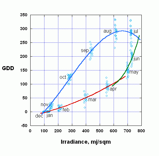
Note that we have plotted the GDD for each month against the accumulated incoming sunlight energy for that month. For example, during September about 225 degree days are accumulated (on average) during the month, for each of the 21 sites, and about 440 million joules of sunlight energy fall on a square meter of ground during the month at each of those sites. Energy was calculated using the software that is available elsewhere on this website.
We then passed smooth curves through these 12 clusters of points. January through April are best fitted with a 2nd degree curve. April, May, and June have been fitted with a 4th degree equation. And the 2nd half of the year has been fitted with a 3rd degree curve. Our software uses these curves to calculate GDD from solar radiation. As an example, suppose we wish to calculate GDD at a particular site during the month of September. Given the latitude of the site we can calculate accumulated irradiance using an algorithm that determines the position of the sun during each day of September, from sunrise to sunset, and the amount of atmosphere the sunlight must penetrate. The result is likely to be between 400 and 500 mj/sqm. Going to the upper (summer/autumn/winter) branch of the GDD versus irradiance curve we will read off a GDD somewhere between 200 and 250 degree days.
If we are interested in the GDD accumulated during an entire growing season (say, April through September) we will calculate the month's GDD for each month of the season and sum them.
You will also notice in the plot above that there is considerable vertical scatter (i.e., variation in GDD) during each month, except during December and January. Most of the scatter is explained by an inverse relationship between site elevation and GDD: the higher in elevation a site is, the lower its monthly GDD; the lower the site, the higher its GDD. As explained below, we have been able to utilize this variation to fine-tune our estimates of GDD.
Our software utilizes the three polynomial fits shown above to calculate GDD from sunlight energy. You should be aware, however, that the sunlight calculations assume a cloudless sky. The algorithm does account for global dimming (an effect of atmospheric pollution), and it does explicitly model the increased thickness of the atmosphere that the radiation must penetrate at low sun angles. In addition we have incorporated a correction for elevation above sea level. This correction is based on a regression analysis of the elevation-related scatter displayed in the plot above. We find, for example, that in July the month's accumulated GDD decreases by about 0.26 Celcius degrees for every one meter increase of elevation. This is roughly comparable to a result reported for West Virginia. Finally, the effect of global warming has also been incorporated into our algorithm (see here).
You will have noted at least two possible deficiencies in this approach. First, the sunlight calculations not explicitly model cloudiness. This means that the actual solar radiation at a site will often be less than the amount we calculate. But remember that the temperature statistics on which actual GDD is based do incorporate the effect of cloudiness, and the three curves in the plot above do in fact establish a tight relationship between actual GDD and full-sunlight irradiation.
Second, there is a great deal of averaging in these calculations. GDD is averaged during each month, and then over a number of years, and finally across a number of sites. But keep in mind two things: when we make an actual GDD estimate for a new site we will make it particular to that site by using a particular latitude and elevation, and a particular field orientation and tilt - all of which move us away from the average and toward the specific. It should also be pointed out that the GDD experienced at any site varies from year to year, and we want a figure that expresses a typical (i.e., average) result.
Although at this writing the algorithm is based on results from sites in western Oregon, we expect in coming months to extend it by including data from central Washington and parts of British Columbia. For the present this is a work in progress and we believe that the algorithm gives realistic results for western Oregon and portions of southwest Washington.